Winter 2009-2010 Forecast Update
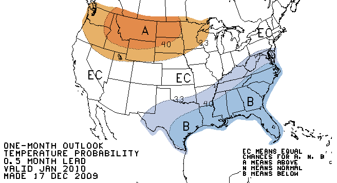
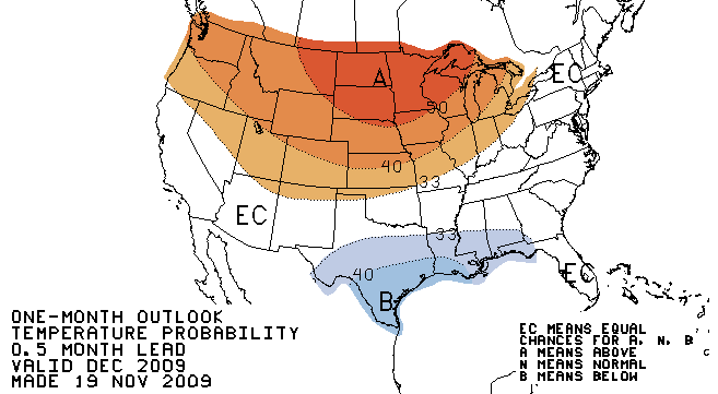
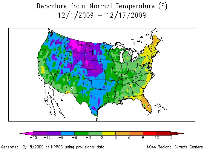
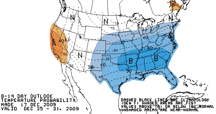
| Three maps are shown on this page: 1. The forecast (Outlook) for December 2009 made on November 19, 2009 2. The departure from normal for temperatures, December 1-17, 2009 3. The forecast (Outlook) for the rest of the month. 4. Updated forecast (Outlook) for January 2010 The forecast for December 2009 is turning out to be quite different than reality. Map 1. The official forecast had only a small portion of the lower 48 states below normal (half of Texas and a small area along the Gulf noted in blue). Map 2. However, as the second map illustrates, almost all of the lower 48 (green and blue colors) is running below normal. Only a small portion of the east coast has had above normal temperatures. Map 3. The forecast for the rest of the month, the third map, indicates that colder than normal temperatures should persist for the rest of the month for much of the lower 48 states with only a small portion of California and Maine predicted to have warmer than normal temperatures. El Nino? El Nino is still out there and has not gone away. The original November 19 forecast for December was based heavily on the normal impact of a developing El Nino. All El Ninos since the 1970's have produced warmer than normal Winters in Nebraska. It appears that an atmospheric "blocking pattern" over the Atlantic is suppressing the impacts of El Nino over the heartland. My colleague, and friend Tom Skilling, WGN TV, summarizes it this way "Greenland blocking pattern returning next 2 wks. It dominated the last 2 winters and played a role in this summer's cool trend. Ridging aloft over Greenland sets up trough over eastern US which promotes surges of cold air into Lower 48. It puts the zonal (westerly) jet stream flow favored in El Nino winter seasons (like this one) on the back burner". ne) on the back-burner from time to time. How long will it least? We had one of our earliest ever snowfalls this October, November 2009 was warmer than October 2009, and now, potentially, the first colder than normal El Nino in over 30 years, I hate to think what strange weather events might come next. This pattern could change in January (and predicted to happen by the CPC, see Map #4) but in the meantime, enjoy an old fashioned cold and snowy December and "White Christmas" in Nebraska. Map 4. The forecast (Outlook) continues to predict that the pattern will shift to a warmer than normal pattern for the Northern Great Plains. |
MAP #1
MAP #2
MAP #3
MAP #4