
 |
 |
|
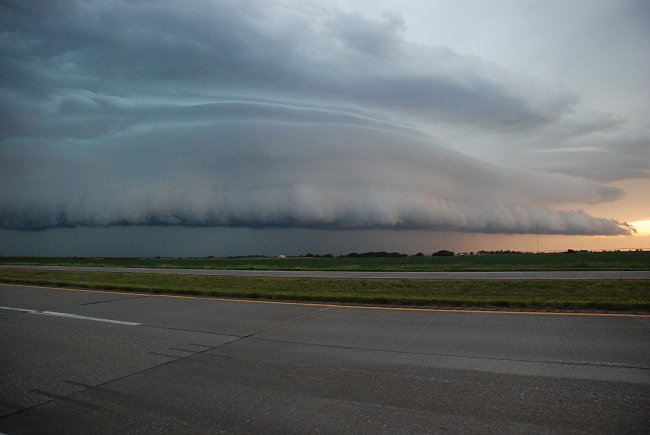
June 1, 2009: A storm moves through Southeast
Nebraska. Photo © K. Dewey. |
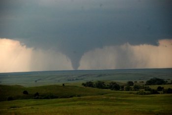
June 5, 2009 tornado near the WY/NE
border. Photo © K. Dewey. LINK to more photos from June 5, 2009 |
Lincoln Heat Wave Climatology (Temperatures >= 90 F; and, >= 100F)
June 1, 2009 Nebraska Storm Photos
Year 2009 U.S. and Nebraska Tornado Update
Year 2009 High Plains Region Precipitation Update
| June 1, 2008 - May 31, 2009 Lincoln Temperature Graph (compared to normal) |
| May 2009 Lincoln Temperature Graph (compared to normal) |
Year 2009 Precipitation
(in inches)
compared to normal: red above
normal, blue below
normal
| 1.52 | 1.17 | 6.18 | . | ||||||||||
Previous Month (May 2009 Lincoln Climate Data)
New daily record precipitation amount of 1.72 inches on June 6, 2009. Old record was 1.41 inches in 1907
ALL June 2009 high temperatures of 90 F or higher are in RED
| Day |
JUNE 2009
|
MAX
|
MIN
|
MEAN
|
DEP
|
PREC
|
PREC |
MAX |
MIN |
HDD
|
CDD | MAX |
MIN |
Mean |
| Monday | +6 | 9 | ||||||||||||
| Tuesday | -1 | 0.17 | 2 | |||||||||||
| Wednesday | -6 | 0.00 | 0 | |||||||||||
| Thursday | -3 | 0.00 | 1 | |||||||||||
| Friday | -2 | T | 3 | |||||||||||
| Saturday | +2 | 1.72 | 7 | |||||||||||
| Sunday | -1 | 0.56 | 4 | |||||||||||
| Monday | -11 | 0.01 | 0 | |||||||||||
| Tuesday | -11 | 0.04 | 0 | |||||||||||
| Wednesday | -5 | T | 1 | |||||||||||
| Thursday | -6 | 0.00 | 1 | |||||||||||
| Friday | -6 | 0.41 | 1 | |||||||||||
| Saturday | -7 | 0.00 | 0 | |||||||||||
| Sunday | -5 | T | 3 | |||||||||||
| Monday | -1 | 7 | ||||||||||||
| Tuesday | +1 | 9 | ||||||||||||
| Wednesday | +7 | 15 | ||||||||||||
| Thursday | 94 | 70 | 82 | +8 | 0.00 | 17 | ||||||||
| Friday | +1 | 10 | ||||||||||||
| Saturday | -1 | 8 | ||||||||||||
| Sunday | 91 | 72 | 82 | +8 | 0.69 | 17 | ||||||||
| Monday | 94 | 70 | 82 | +7 | 0.82 | 17 | ||||||||
| Tuesday | 99 | 74 | 87 | +12 | 0.00 | 22 | ||||||||
| Wednesday | 90 | 71 | 81 | +6 | 0.01 | 16 | ||||||||
| Thursday | 93 | 71 | 82 | +7 | 0.00 | 17 | ||||||||
| Friday | 91 | 71 | 81 | +5 | T | 16 | ||||||||
| Saturday | -1 | 10 | ||||||||||||
| Sunday | -5 | 6 | ||||||||||||
| Monday | 91 | 60 | 76 | 0 | 0.00 | 11 | ||||||||
| Tuesday | -4 | 7 | ||||||||||||
| 2482 | 1853 | 6.18 | 12 | 237 | ||||||||||
| 82.7 | 61.8 | 72.3 | ||||||||||||
|
DEPARTURE
|
-2.2 | +1.4 | -0.4 | +2.67 | -4 | -7 |
Lincoln, Nebraska Top Ten Wettest and Driest Months Data record 1887 to Present Precipitation measurement units are "inches" JUNE
From the record books: Warmest recorded JUNE temperature, 108 F, June 15, 1946 AND June 26, 1936. Coldest recorded JUNE temperature, 39 F, June 8, 1978. NORMAL (Norm) is the 1971-2000 Standard Normals. DEPARTURE is JUNE 2000 Average measured against 1971-2000 normals. MAX = Observed Maximum and MIN = Observed Minimum temperatures. MEAN = Observed Mean Daily temperature. DEP = Departure from normal ( _ = below normal, + above normal). PREC = Observed daily precipitation (midnight to midnight, CST) in inches. REC PREC = Record daily amount of precipitation in inches. REC MAX = Record maximum temperature in deg. F. REC MIN = Record Minimum temperature in deg. F. HDD = heating degree day units (base of 65 degrees). CDD = cooling degree day units (base of 65 degrees). Norm MAX = Daily Normal High Temperature (1971-2000 normals). Norm MIN = Daily Normal Low Temperature (1971-2000 normals). Norm MEAN = Daily Normal Mean Temperature (1971-2000 normals).
|